History of The Barbados Railway
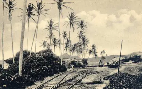

A train may seem an unlikely character in the story of a Caribbean island known for sea views, rum shops, and cane fields. Yet the old train in Barbados circa 1880s was a real sign of a changing island: one trying to move sugar, people, news, and commerce more quickly between Bridgetown and rural communities. Its story is not simply one of Victorian engineering. It is also a window into the wealth and hardship of the sugar economy, the shape of island life, and the routes that still guide travelers through Barbados today.
The Old Train in Barbados Circa 1880s
Barbados entered the railway age in 1881, when the Barbados Railway opened its first line. The early route connected Bridgetown with the eastern side of the island, passing through country districts where sugar estates dominated the landscape. By the 1880s, rail was still new, ambitious, and very much tied to the movement of agricultural goods.
The island’s terrain made the undertaking more complicated than it might sound. Barbados is compact, but it is not flat. Beyond the west and south coasts, roads climb into ridges, dip through gullies, and cross the rolling heart of the island. Building and maintaining a railway through that landscape required investment, labor, bridges, cuttings, and plenty of determination.
For passengers, the railway offered a different sense of distance. A trip that had once depended on a horse, cart, or long road journey could now follow a scheduled route toward town. For estate owners and merchants, trains offered a more efficient connection between cane-growing districts and Bridgetown’s commercial activity. That is the practical side of the story. The human side is more layered.
A Railway Built During the Sugar Era
In the 1880s, sugar remained central to Barbados. Cane fields were not merely scenery. They were workplaces and sources of wealth, shaped by the difficult legacy of slavery and the unequal labor conditions that continued after emancipation. The railway served an economy that was already deeply organized around plantations, export, and the port.
That context matters when looking at an old railway image. A steam locomotive, tidy station platform, or rail bridge can appear wonderfully romantic from a distance. But railways did not arrive on a blank canvas. They moved through communities where working people were navigating low wages, limited opportunity, and the daily realities of a colonial economy.
At the same time, the train became part of ordinary Bajan life. It carried passengers, linked villages, and gave residents a new way to encounter the island beyond their immediate district. Like railways almost everywhere, it was both a business tool and a public event. The sound of a train arriving could turn heads, change plans, and connect a rural stop to the bustle of Bridgetown.
What a journey may have felt like
Picture a traveler leaving the capital in the late nineteenth century. The city’s wharves, warehouses, churches, and market activity gradually gave way to open country. Cane fields stretched across the slopes. Small settlements appeared along the route, and the air changed as the line climbed away from the coast.
The ride would not have offered the silence of a modern electric bike. There would have been the clatter of wheels, smoke from the locomotive, heat, dust, conversation, and the occasional delay that comes with operating machinery in a tropical island environment. Still, it brought a sense of modernity to a place whose roads and trade patterns had long been shaped by horses and carts.
Why the Railway Followed the Land
The old rail routes are a reminder that Barbados’s geography has always directed its history. The island’s relatively gentle western and southern corridors made certain connections easier, while central and eastern elevations demanded more careful planning. Tracks had to work with steep gradients and changing ground conditions rather than simply charge across the countryside.
That is why the railway story belongs alongside the island’s landscape story. The same hills that now reward visitors with sweeping views also tested engineers. The same cane country that looks peaceful in the afternoon sun was once a busy agricultural network, with workers, carts, factories, and transport systems all moving to the rhythm of harvest.
On the rugged Atlantic side, places such as Bathsheba and the high ground around Hackleton’s Cliff reveal the island’s dramatic contours particularly well. They are not railway sightseeing stops in the way they might have been in the 1880s, but they help explain the physical Barbados that rail planners had to reckon with. A map looks simple. The land, as usual, has its own opinion.
The Old Train Was Not Barbados’s Final Transport Story
The railway expanded beyond its earliest line and remained part of island life well into the twentieth century. Over time, however, road transport became more flexible. Motor vehicles could reach destinations without the enormous cost of laying and repairing track, and buses and trucks increasingly took over passenger and freight duties.
The railway ultimately closed in 1937. Its end was not proof that it had failed to matter. Rather, it reflected changing technology, finances, transport needs, and the practical challenges of maintaining a rail system on a small island. Rail can be efficient where large volumes travel along fixed corridors. For a compact island with evolving roads and dispersed communities, trucks and buses offered a different kind of freedom.
Today, many visitors expect Barbados history to be contained in forts, plantation houses, churches, and Bridgetown’s historic streets. Those places are essential, but the railway deserves a place in the conversation too. It shows how the island linked countryside to capital, how sugar shaped infrastructure, and how global Victorian ideas reached a Caribbean society on its own terms.
Reading the Landscape After the Tracks Are Gone
You do not need to find rails in the ground to understand the old railway. Start by noticing how settlements cluster along passable routes and how roads thread through former cane country. Look at the relationship between elevated interior districts, coastal towns, and Bridgetown’s harbor. Transport has always been about those connections.
In Bridgetown, the story becomes especially clear. The capital was the island’s commercial engine, where imports arrived and exports departed. Rural produce and people flowed toward the city, while goods, information, and opportunity flowed back outward. The railway was one chapter in that exchange, alongside maritime trade, road travel, and the enduring importance of the port.
A good local guide can make these connections feel less like a history lesson and more like a living map. On a countryside ride or heritage walk, a church tower, an old estate boundary, a gully, or a village road can become a clue to how people moved through Barbados generations ago. At eBike Barbados, our guides enjoy those moments because the island’s best stories are often hiding in plain sight – usually just beyond the busy resort corridor.
Keep the questions bigger than the locomotive
When you come across a photograph or reference to the old train in Barbados, ask more than what model of locomotive it was or where the station stood. Ask who built the system, who used it, whose work sustained the economy around it, and what the route changed for nearby communities.
Those questions give the railway its proper scale. It was an engineering project, certainly, but it was also part of an island negotiating colonial rule, agricultural dependence, social change, and new ideas of movement. That makes it far more interesting than a vanished set of tracks.
The next time you travel through Barbados’s green interior or pause above the Atlantic coast, take a moment to read the land as the old railway once did: not as a backdrop to rush past, but as a place full of routes, labor, memory, and stories still waiting for a good Bajan to tell them.