The History of Cherry Tree Hill, Barbados
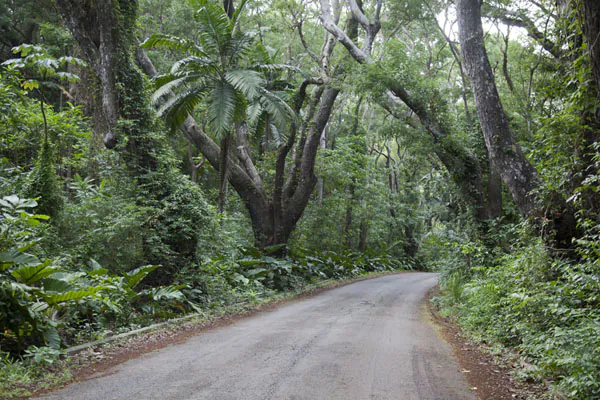

At the crest of Cherry Tree Hill, the island changes character. The sea ahead is Atlantic blue and restless, the land below folds into gullies and ridges, and a cool breeze often cuts through the heat. The history of Cherry Tree Hill Barbados is not simply the story of a scenic stop. It is a story of changing forests, plantation-era land use, African-Barbadian resilience, and a landscape that has long offered one of the island’s most revealing views.
For visitors who know Barbados mainly by its west-coast beaches, Cherry Tree Hill is a proper change of scene. This is the wilder, hillier side of the island, where the road opens toward the Scotland District and the coast feels shaped by wind rather than hotel towers.
Where Cherry Tree Hill Gets Its Name
Cherry Tree Hill sits on a high ridge in the parish of St. Andrew, along one of the island’s most memorable inland roads. Its name is generally linked to cherry trees that once grew in the area. The original trees are gone, and that distinction matters: the grand trees visitors see lining the roadway today are predominantly mahogany, not the cherry trees that gave the hill its name.
That small detail is a useful reminder that landscapes are living records, not museum displays. Names can preserve what has disappeared. A visitor may stand under a canopy of mahogany while the place name quietly recalls a different, older planting pattern.
The avenue itself has become part of the attraction. Tall mahogany trees frame the road, their branches making a green tunnel before the view breaks open dramatically toward the east. You will sometimes hear confident claims about the exact age of every tree or the date they were planted. Local stories are part of the charm, but a good guide will separate well-known tradition from what can be firmly documented. The real point is clear enough: these trees have helped make the ridge a landmark for generations.
A View Into Barbados’s Oldest-Looking Country
From Cherry Tree Hill, look down toward the Scotland District and you are looking at a part of Barbados unlike much of the island. The terrain is steep, deeply eroded, and geologically distinct from the flatter coral limestone landscapes farther south and west. Its folded hills, gullies, and exposed slopes have earned it a reputation as Barbados’s rugged heartland.
The view often takes in the Atlantic-facing country around St. Joseph and St. Andrew, with the coastline beyond. On a clear day, the scene seems almost too expansive for an island only 21 miles long. Cane fields, homes, grazing land, palms, and wooded ravines all appear in the same sweep.
That geography shaped daily life. Travel across the eastern parishes was historically slower and more demanding than movement along flatter routes. Communities here developed around estates, churches, village roads, and small-scale cultivation, with people adapting to slopes, rain, and soils that behaved differently from the broad sugar-growing plains.
It is tempting to call this untouched Barbados. It is not. The landscape has been worked, planted, grazed, settled, and traveled for centuries. Its beauty comes partly from that long relationship between people and place.
Cherry Tree Hill and the Plantation Landscape
To understand the history of Cherry Tree Hill, Barbados, it helps to see the ridge within the bigger story of colonial land ownership. After English settlement began in the 17th century, Barbados was transformed by the sugar economy. Forests were cleared, estates expanded, and enslaved Africans were forced to provide the labor that created immense wealth for plantation owners and imperial trade.
St. Andrew and neighboring eastern parishes were part of that system, even where the topography made large-scale cultivation more complicated than on flatter land. Estate boundaries, former cane lands, old access routes, and historic village patterns remain written across the countryside, though they are not always obvious from a roadside lookout.
The view from the hill should never be treated as a postcard without people in it. Barbados’s plantation economy was built on violence and exploitation. Enslaved Africans resisted in many ways: by preserving cultural practices, building family and community ties under impossible conditions, refusing compliance where they could, and carrying knowledge of land, food, and survival across generations.
Emancipation in the 1830s changed the legal status of formerly enslaved Barbadians, but it did not instantly redistribute land or erase inequality. Rural families continued to build lives through wage work, farming, trades, migration, faith communities, and determined mutual support. The villages and cultivated slopes visible from Cherry Tree Hill are part of that ongoing history, not a backdrop to it.
The Road as a Route Through Real Barbados
A great viewpoint is useful. A great route is better. Cherry Tree Hill works because it connects naturally with places that reveal different sides of the island: the dramatic surf and rock formations of Bathsheba, the sweeping Atlantic outlook at Hackleton’s Cliff, working countryside near Malvern Plantation, and the trails and agricultural landscape around PEG Farm.
These places are not interchangeable photo stops. Bathsheba tells a story about the Atlantic coast and the power of the sea. Inland ridges show how geology has directed settlement and farming. Plantation areas invite honest conversations about sugar, labor, and land. A route through them becomes more meaningful when you leave enough time to notice the transitions.
That is also why a small-group outing suits this part of Barbados better than rushing through in a large coach. Roads can be narrow, weather can shift, and the best moments are often unscripted: a green monkey crossing a field, a osprey hovering over the sea, or a local telling you which fruit is in season. There is no need to march around like you are training for the Olympics. The hill country is best enjoyed at a sensible pace.
Mahogany, Monkeys, and the Nature of the Ridge
Cherry Tree Hill is remembered for its trees and panorama, but its natural life deserves equal attention. Mahogany provides shade and structure along the road, while surrounding vegetation supports birds, insects, reptiles, and the occasional Barbados green monkey. Bring binoculars if birding is your thing, but keep your eyes open even without them. Frigate birds, black whiskered vireos, and Eurasian collared doves are often part of the soundtrack in rural Barbados.
The ridge can feel noticeably cooler and breezier than coastal resort areas. That makes it pleasant for an active outing, although conditions depend on the season. After rain, roads and tracks can be slick. During the drier months, sun protection and water remain essential, even beneath a handsome old canopy.
Wildlife etiquette is simple. Watch quietly, avoid feeding animals, and do not treat the trees or roadside banks as props for climbing. These landscapes are shared spaces, used by residents, farmers, drivers, and wildlife alike.
How to Experience Rural Barbados the right way
The most rewarding visit is not necessarily the longest one. Give yourself time to stand at the lookout, take in the scale of the Scotland District, and listen to the story behind what you are seeing. Then continue into the surrounding east and north countryside rather than turning straight back toward the beach.
If you are comfortable riding, an electric bike is a particularly enjoyable way to approach the ridge. The pedal assist takes the sting out of rolling grades, so mixed-ability couples, families, and friends can travel together without one person being left panting at the back. You still get the fresh air, the birdsong, and the satisfying feeling of arriving under your own power – just with a helpful little boost when the road decides to get cheeky.
Practical preparation makes a difference. Wear closed-toe shoes, use sunscreen, carry water, and bring a light rain layer if the forecast looks unsettled. On narrow rural roads, stay alert for vehicles and follow your guide’s safety instructions. Visitors driving themselves should not block local traffic while stopping for photographs, however tempting that view may be.
For travelers staying far from the eastern parishes or visiting by cruise ship, transport can be the deciding factor. A guided experience with pickup removes the worry of navigation, parking, and watching the clock. At eBike Barbados, local guides pair that convenience with the kind of historical context that turns a beautiful ridge into a place you genuinely understand.
This part of the island asks very little of you: pause, look beyond the trees, and let the view introduce you to a Barbados shaped by far more than sun and sand.