Coral vs. Limestone: Barbados’ Key Difference

Stand at the edge of Hackleton’s Cliff or look across the layered terraces above the west coast, and Barbados starts telling a very old story. The difference between coral and limestone as it relates to Barbados is not just a geology lesson for a rainy afternoon. It explains why parts of the island rise in broad steps, why rainwater disappears underground, why some coastlines are calm while others meet the Atlantic with full force, and why the landscape changes so quickly over a short ride.
For visitors, the easy shorthand is that Barbados is a coral island. That is broadly true, but the fuller story is more interesting: coral is a living animal, while limestone is a rock. Coral can become part of limestone over a very long time, but the two are not interchangeable. Once you see the distinction, the island’s cliffs, caves, soils, reefs, and ridge-top views make a lot more sense.
Coral vs. limestone in Barbados: the simple answer
Coral is a colony of tiny marine animals called polyps. Some corals build hard skeletons made largely of calcium carbonate, the same mineral family found in many shells. In warm, shallow, clear seawater, those skeletons can accumulate alongside shell fragments, algae, and other marine material to form reefs.
Limestone is the sedimentary rock that can result when calcium-carbonate material is compacted and cemented over thousands to millions of years. Coral fragments may be a major ingredient in limestone, but limestone can also contain shells, microscopic marine organisms, and chemical deposits from seawater. Think of coral as one contributor to a much bigger geological recipe.
In Barbados, much of the island is made from coral limestone – ancient reef and seabed material that was lifted above sea level. That uplift created the raised coastal terraces that give Barbados its distinctive stepped shape. So when someone calls a white cliff or inland ridge “coral,” they usually mean it was formed from old reef material. It is more precise to call the rock coral limestone.
How an ancient seabed became Barbados
Barbados sits near the eastern edge of the Caribbean, where powerful forces beneath the sea have been shaping land for a very long time. As the island was gradually raised, former shorelines and reef platforms were left high and dry. New reefs formed near sea level, then those were lifted too. Repeat that process enough times and you get the series of terraces visible across much of the island.
The island is not made of one uniform layer, though. The Scotland District in the northeast is especially different. Its rolling, folded terrain includes much older sedimentary material associated with the geological processes that built the island. It is a reminder that Barbados is more varied than the postcard version of flat beaches and turquoise water.
That contrast is part of what makes an inland or east-coast outing so rewarding. One moment you can be looking across cane fields and limestone ridges; the next, near Bathsheba or the wilder Atlantic side, the ground, vegetation, and ocean mood feel entirely changed. Barbados is compact, but it does not do boring.
The terraces are former coastlines
Those broad, gently sloping shelves across the island are not accidental. Many are ancient reef surfaces that once sat near the sea before uplift carried them higher. They help explain why roads and communities often occupy relatively level ground, while certain routes suddenly tip toward a ravine, gully, or cliff.
On a clear day, elevated places such as Mount Hillaby reveal this structure beautifully. The view is not simply “a nice lookout.” It is a chance to read a former marine landscape now standing far above the water that created it.
Living coral reefs are not limestone cliffs
A modern coral reef is a living ecosystem. It provides shelter, feeding grounds, and nursery habitat for fish and many other marine species. Healthy reef systems also help absorb wave energy, which matters greatly for island shorelines.
A limestone cliff, by contrast, is land-based rock. It may have begun as a reef long ago, but it is no longer a living coral community. This is why visitors should avoid using “coral reef” to describe every pale coastal rock formation they see. The words sound similar, but one describes a living marine habitat and the other describes a rock record of ancient environments.
The distinction also matters for responsible travel. Living corals are delicate. Kicking, standing on, touching, or collecting pieces from a reef can damage animals that took decades to grow. Even where a reef looks like a solid surface, it is often a busy, fragile neighborhood. Enjoy it with your eyes, fins, and a respectful bit of distance.
Why limestone shapes the island experience
Limestone is porous and dissolves gradually when slightly acidic rainwater moves through cracks. Barbados receives plenty of rain, especially in the wetter months, and much of that water filters down through the limestone rather than running across the surface.
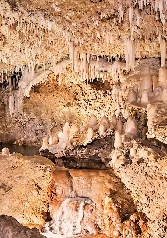
That process has created gullies, underground channels, caves, and springs. Harrison’s Cave is the famous example, but the broader pattern appears all over the island in the way land rises, dips, drains, and suddenly opens toward the coast. It also helps explain why the island has fewer large, constantly flowing rivers than visitors might expect from a tropical destination.
Limestone influences the soil as well. In many areas, soils are thin, alkaline, and rich in calcium. They support particular plant communities and have shaped generations of farming. Sugar cane became deeply tied to the island’s history and economy for many reasons, including climate, labor, trade, and colonial policy, but the physical character of the land was part of that story too.
There is a practical side for walkers and riders. Limestone terrain can mean uneven surfaces, loose pale stones, sharp edges, and steep gullies after rainfall. The island’s countryside is welcoming, but it deserves proper footwear for hikes and steady attention on two wheels. A little trail dust is part of the souvenir package.
Barbados’ east coast tells a different story
The east coast is where visitors can feel the difference between geology and geography under their feet. The Atlantic meets Barbados with stronger wave energy than the generally calmer Caribbean-facing west coast. At Bathsheba, surf works against rocky shorelines while trade winds sweep across the landscape. The famous dramatic formations are shaped by erosion, weather, and the island’s layered geology, not by living coral alone.
Further inland, the ridges and countryside lanes around places such as Villa Nova, Venture and Malvern Plantation offer a different view of the same story. You are moving across an island built from the sea, yet surrounded by farms, birdlife, old settlement patterns, and communities with histories that run much deeper than any vacation itinerary.
It depends on where you go, of course. A west-coast beach visit may show you calm water, sand, and nearshore reefs. A hike along an east-coast ridge may reveal weathered rock, expansive ocean views, and more rugged ground. Neither is more “real” Barbados. Together, they show why the island has so much character packed into 166 square miles.
What to look for when you are out exploring
You do not need to carry a geologist’s hammer – please leave the cliffs alone anyway – to spot the relationship between coral and limestone. Look for pale, layered rock in roadside cuts and cliff faces, rounded shells or fossil traces embedded in stone, and terraces that seem to run parallel to the coast.
Notice how gullies cut through the countryside and how certain areas drain quickly after a shower. Watch for changes in vegetation as elevation, soil depth, wind exposure, and moisture shift. Along the coast, ask whether you are looking at a living reef, a wave-cut limestone feature, or sand made partly from broken-down marine material. Good local guides love those questions because they turn a pretty view into a story.
A better way to see Barbados’ geology
The real joy of understanding coral and limestone is that it encourages you to slow down. Instead of seeing a ridge as just a photo stop, you can recognize an ancient reef terrace. Instead of seeing a gully as a shortcut for rainwater, you can see limestone at work. Instead of treating the coast as one long beach, you begin to notice the island’s changing faces.
That is the sort of perspective a small-group outing can bring to life. With eBike Barbados, guests can travel through countryside and coastal landscapes at a comfortable pace, with a fun, laid-back local guide connecting the views to Bajan history, wildlife, and everyday island life. Pedal assist helps mixed-ability groups enjoy the hills together, while pickup and drop-off remove the headache of getting to the trailhead.
Bring water, sun protection, and curiosity. Barbados was built from the sea, raised by time, and shaped by the people who have made their lives upon it – and the next limestone ridge may have more to say than you expect.