The Geology and Formation of Barbados Explained
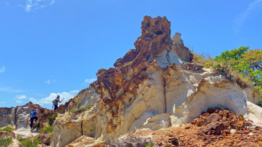

A ride across Barbados can feel like several islands stitched into one. One moment you are rolling past cane fields on a high, breezy terrace; the next, the road drops toward dramatic Atlantic surf at Bathsheba, where boulders sit in the shallows like they were placed there on purpose. They were not, of course. The geology and formation of Barbados explain why this small island has such a varied landscape – and why the view changes so quickly when you leave the resort coast behind.
Barbados is not a volcanic island in the usual Caribbean sense. There is no dormant volcano under the island waiting to make a comeback. Instead, Barbados was built slowly from the seafloor upward, shaped by the collision of tectonic plates, layers of sediment, growing coral reefs, uplift, rain, and relentless wave action. It is a grand geological story, but you can see its evidence on an ordinary country road, a coastal trail, or from a lookout on the island’s eastern edge.
The geology and formation of Barbados begins beneath the sea
Barbados sits near the eastern edge of the Caribbean Plate, where it meets material moving beneath it from the Atlantic side. For millions of years, sediments from the Atlantic seafloor were scraped, squeezed, and piled up as one plate moved beneath another. Geologists call this kind of feature an accretionary prism – think of it as a very slow-moving geological bulldozer pushing mud, sand, and older ocean sediments into a rising mass.
That process gave Barbados its foundation. The island began to emerge above sea level roughly a million years ago, although the rocks beneath it tell a much older story. Unlike nearby islands with peaks formed by lava, much of Barbados is made of sedimentary material and limestone. That difference matters when you are looking at the landscape. Barbados tends toward rolling uplands, stepped terraces, gullies, caves, and broad coral shelves rather than volcanic cones and black-sand beaches.
The island is still being lifted, bit by bit, by the tectonic forces below. This uplift is one reason Barbados has a remarkable sequence of raised coral reefs. What was once a shoreline can eventually become a hillside. Not bad for an island that many visitors first meet from a beach chair.
Coral limestone built the island we recognize today
Once parts of the rising land sat in warm, shallow water, coral reefs flourished around them. Corals, calcareous algae, shellfish, and other marine life created calcium-rich deposits that hardened over time into limestone. During periods when sea level was higher, reefs formed close to the coast. When sea levels fell or the land rose, those reefs were left high and dry.
This happened repeatedly over hundreds of thousands of years. The result is a series of coral terraces, particularly visible across much of the west, south, and central island. These terraces create Barbados’s characteristic stairstep profile: relatively level areas separated by slopes or escarpments. They have influenced where roads run, where towns developed, and how farming spread across the countryside.
The limestone also helps explain the island’s pale cliffs, rocky coves, and underground features. Rainwater absorbs a little carbon dioxide as it passes through the air and soil, becoming mildly acidic. Over long periods, it dissolves limestone along cracks and weak points. This creates sinkholes, gullies, and caves, including the well-known underground chambers found in central Barbados like Harrison’s Cave.
It also affects water. Barbados has no large rivers like those found on wetter volcanic islands because rain often drains through porous limestone rather than flowing for miles across the surface. Underground aquifers are therefore especially important to the island’s freshwater supply. After a heavy shower, you may see water rushing through a gully, but much of it is already finding a route downward through the rock.
Why the west and east coasts look so different
The gentler Caribbean coast on the west side of Barbados is protected from the full force of the Atlantic. It is known for calmer water, sandy bays, and nearshore reefs. The east coast faces the open Atlantic, where stronger waves and currents pound the shore year-round. That energy cuts cliffs, shifts sand, exposes rock layers, and gives places such as Bathsheba their wild, sculpted appearance.
Bathsheba’s famous offshore rocks are erosional remnants – harder or more resistant material left standing as waves wear away the surrounding sediments. Sea anemones also inspired the name of one well-known formation, Mushroom Rock. Depending on tide and swell, the shoreline can look peaceful, moody, or properly dramatic. The Atlantic does not do boring.
Scotland District: Barbados’s oldest-looking landscape
For many visitors, the Scotland District is the island’s geological plot twist. Located mainly in the northeast, it looks less like the flatter coral-limestone country elsewhere in Barbados and more like a deeply folded, rugged landscape. Its ridges, valleys, exposed slopes, and clay-rich soils reveal some of the island’s oldest material.
This area contains sedimentary rocks and deposits associated with the island’s early formation, including clays, sands, and materials that were once deep beneath the ocean. Erosion has carved the terrain into steep gullies and irregular hills. It is beautiful country, but it is also geologically delicate. Heavy rainfall can trigger erosion and landslips, especially where slopes have been cleared or drainage is poor.
The Scotland District reminds us that Barbados is still changing. Not at a pace you will notice between breakfast and sunset, thankfully, but through natural processes that continue to reshape the land. Coastal erosion, slope movement, wave action, and groundwater all leave their mark.
From overlooks around Hackleton’s Cliff and along routes toward the Atlantic side, the elevation and shifting ground tell a story that a beach map cannot. You are looking across an island that has been lifted from the sea, then weathered into a patchwork of ridges, fields, villages, and ravines.
How geology shaped Bajan history and daily life
Geology is not just a science lesson tucked away in a cliff face. It helped shape settlement, agriculture, architecture, and movement around Barbados. Fertile soils in many districts supported sugar cane cultivation for centuries, while the land’s ridges and terraces influenced estate boundaries, road routes, and the location of communities.
Limestone was also a practical building material. Coral stone appears in older churches, walls, homes, and historic structures across the island. In Bridgetown, the relationship between land and sea has always mattered too. The natural harbor area, coastal access, and relatively sheltered western waters helped the city develop into a major trading port during the colonial era.
On the east coast, communities adapted to more exposed conditions: salt air, strong winds, rough seas, and steep terrain. Fishing traditions, farming practices, and village life developed around the character of the landscape. That is why the best local stories often connect a place to the ground beneath it. A ridge is never only a ridge. It may have been a route to market, an estate boundary, a lookout, or the setting for a bit of Bajan folklore.
Seeing Barbados’s geology beyond the beach
You do not need a hard hat or a geology degree to notice these patterns. Start by watching how the landscape changes as you travel from the west or south toward the interior and east. The roads rise. The breeze cools. Cane fields open up. Then the terrain becomes more folded, more rugged, and more exposed to the Atlantic.
At Edge Cliff, elevated views make the island’s layered topography easier to appreciate. Around PEG Farm and the countryside beyond, the mix of open farmland, gullies, and coastal terrain shows how soils, rainfall, and slope affect what grows where. At Bathsheba, look beyond the surf pools and notice the cliffs, headlands, and weathered rock formations. They are the visible edge of a much larger tectonic story.
For an active day outdoors, conditions matter. East-coast trails can be uneven, coastal paths may be slippery after rain, and strong sun arrives with very little ceremony. Closed-toe shoes, water, sun protection, and a light rain layer are sensible choices. If you are riding, a pedal-assist eBike is a friendly way to handle Barbados’s rolling grades without turning the day into an endurance test. The hills are part of the fun, but nobody needs to prove anything to them.
A knowledgeable local guide can also help turn scenery into context: why one field sits high above the sea, why another valley drains so quickly, or why a particular cliff is vulnerable after heavy weather. eBike Barbados builds that kind of local interpretation into its small-group experiences, with the practical bonus of organized transportation and equipment so guests can focus on the landscape rather than the logistics.
The next time you stand above the Atlantic, pause before taking the photo. Look at the raised land behind you, the broken rock below, and the reef-fringed water stretching out ahead. Barbados is still telling the story of its making – you just need to give the ground a moment to speak.